
Britain is braced for another major wintry blast later this month, with fresh weather maps indicating a widespread 'snow bomb' is set to hit the country. The significant snowfall is forecast for Monday, 26 January, and follows closely on the disruption caused by Storm Goretti last week.
Extensive Snow Cover Forecast
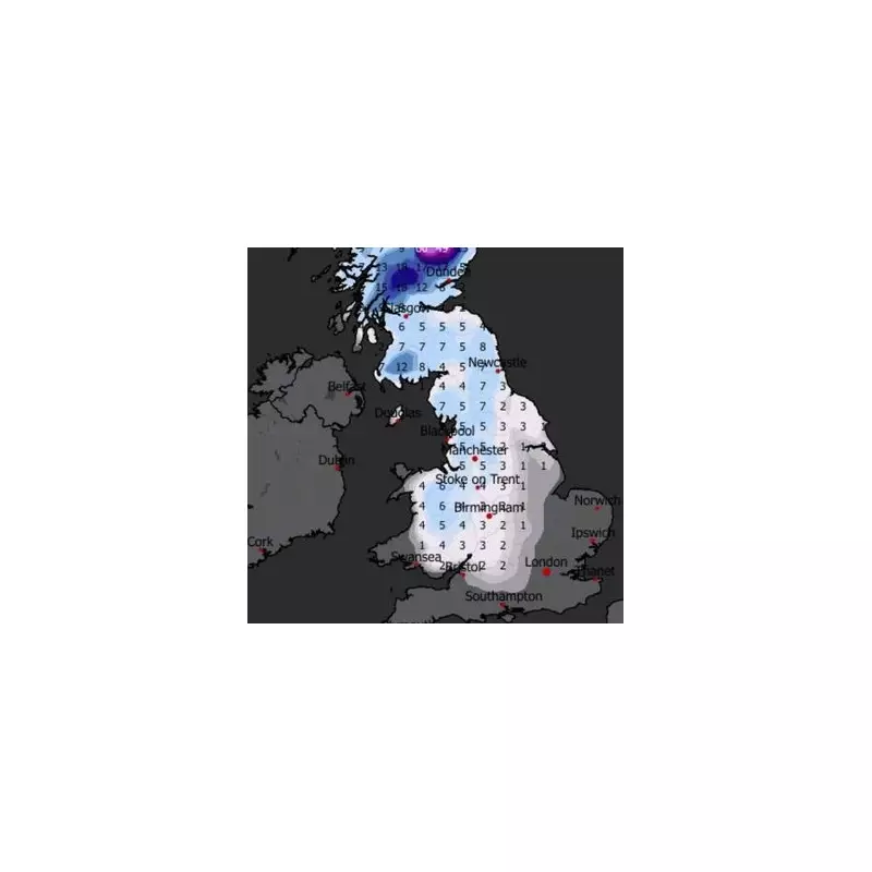
According to detailed projections from WXCharts, a vast swathe of the United Kingdom will see snow on the 26th. The predicted whiteout stretches from the northernmost parts of Scotland right down to southern England, threatening to bring travel disruption and hazardous conditions to millions.
Meteorological data suggests the snowfall will be extensive, though forecasters indicate the levels are not expected to be as severe as the accumulations witnessed in the West Midlands during the recent storm. Nevertheless, the fresh bout of wintry weather could compound existing issues across the region.

Which Counties Will Be Spared?
Only a select few counties are currently predicted to escape the brunt of the snowfall. These are primarily located along the south coast and in the east of England. The areas expected to be spared include:
- Cornwall
- Devon
- Kent
- Essex
- Suffolk
- Norfolk
Residents in these regions may see rain or sleet instead, but significant snow accumulation is considered unlikely based on current models.
Met Office Warns of Winter Hazards
The Met Office has echoed the potential for difficult conditions in its long-range forecast for the end of January. It states that while temperatures will likely be near normal overall, there is a distinct possibility of colder spells, particularly in the north and east.
The national forecaster's outlook explicitly mentions "the potential for associated winter hazards." It describes the period as remaining changeable, with further spells of rain and wind likely, especially in western areas. However, there should also be drier interludes, more probable in the east.
The forecast concludes by noting a potential weather split developing late in the period, with wetter conditions possibly becoming confined to the north and northwest, while drier weather establishes in the south and southeast. For now, all eyes are on the significant snow event predicted for Monday, 26 January.


