UK weather maps show the most intense heatwave of the summer yet is still to hit England. A fourth - and more intense - heatwave is being projected to roast the country in August as the sweltering summer continues.
Forecast Details
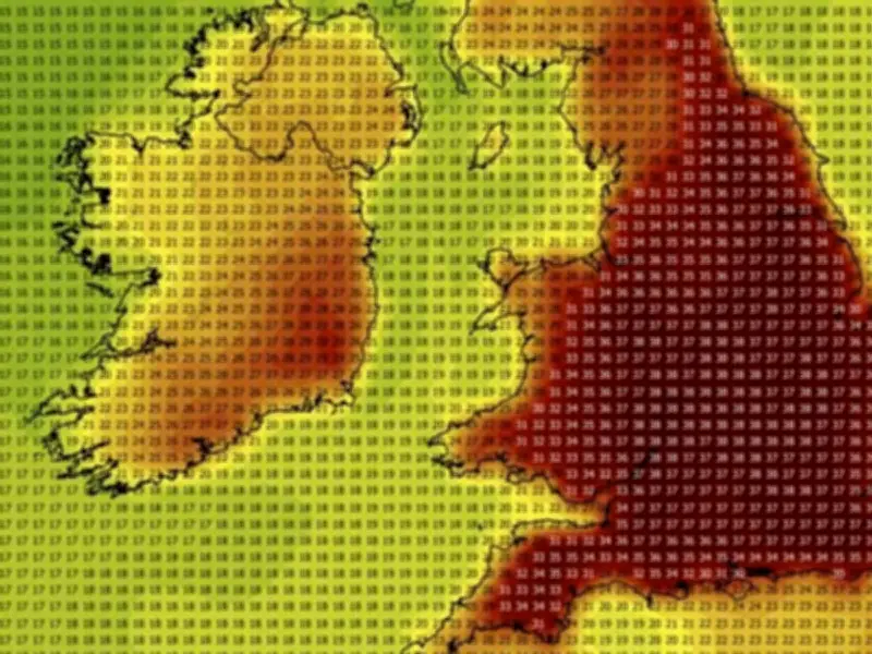
Maps from WX Charts, using the GFS advanced modelling system and Met Desk data, show 33C heat returning from July 27 into the latter stages of the month, with the prospect for 37C by July 29, just two days before the eighth month of the year begins. Maps have burned red, burgundy and even black as the stifling conditions are tipped to return, bringing with it the highest mercury recorded of the summer so far.
The maximum temperature maps from the forecasters, which have seen their predictions echoed by rival charting sites like Ventusky, show 37C at the peak and 35C to 33C heat widespread.

Climate Context
It comes as the UK faces the third deadly heatwave to have scorched Europe over the last two months. On Tuesday, the Met Office said the UK had already recorded as many 30C (86F) days in 2026 as 1976.
“What we used to think of as extreme, we increasingly consider as normal,” said Mike Kendon, a scientist at the National Climate Information Centre and lead author of the report. “We are seeing unprecedented changes continuing … and every year adds to this body of evidence.”
“Our climate is on the move – literally,” said Kendon. “The trend shows that in the 1980s, annual average temperatures of 11C were virtually unknown in the UK, yet by 2025 almost a fifth of the land surface reached that value.”
Met Office Outlook
A July 24 to August 2 forecast from the Met Office says: "Dry on Friday for most with sunny spells. Northern and northwestern areas will be cloudier with occasional patchy rain or drizzle.
"Into the weekend and perhaps the start of next week, more unsettled weather with rain at times, especially across northern parts of the UK. This rain may very well reach southern areas too, but could become more light and patchy here.
"Confidence becomes lower as we approach the turn of the month, but there are signs that high pressure will return, which means dry conditions would resume, especially in the south.
"Winds will be mostly light or moderate, occasionally fresh around northern coasts. Temperatures are expected to be near or above normal, warmest in the south, perhaps becoming very warm again by the start of August."