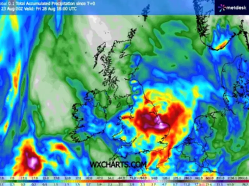
Weather maps indicate that the Midlands will experience torrential downpours and widespread thunderstorms over the coming week, as a 'Spanish plume' weather system moves across the UK. The UKMO weather model shows that some parts of the country could receive as much as 90mm of rainfall between now and Friday, providing a welcome respite following record dry spells and the declaration of drought conditions across portions of England and Wales.
Eastern England and Midlands to bear the brunt
Eastern parts of England are expected to see the heaviest rainfall throughout the week, though the data also points to significant downpours across North Wales, the north-west, the Midlands and areas of the south-east. Overall, the data indicates that as many as 20 counties could receive 40mm of rain by Friday, all located in England and Wales.
The counties bracing for heavy rainfall include Yorkshire, Lincolnshire, Nottinghamshire, Derbyshire, Leicestershire, Cheshire, Shropshire, Staffordshire, Warwickshire, Northamptonshire, Cambridgeshire, Norfolk, Suffolk, Essex, Sussex, Oxfordshire, Bedfordshire, Flintshire, Denbighshire and Caernarfonshire.

What is a Spanish plume?
BBC Weather forecasters have said that a "Spanish plume type of system" could trigger "thundery outbreaks" across the UK next week. A Spanish plume is a meteorological phenomenon describing warm air travelling northwards from Spain that rises and cools, resulting in the development of thunderclouds.
The Met Office explains: "As cooler air spreads from the west, instability increases and the very warm air rises through the cooler air, enhancing the formation of thunderstorms. The very warm air from Spain forms a layer at height and acts as a lid, initially preventing warm air rising from the surface. However, as the air at the surface increases in temperature eventually it warms enough to break through this barrier and air can then rise from the surface up to the higher parts of the troposphere."
Temperature forecast and relief from drought
The Met Office adds: "This air is very unstable and the dramatic release of energy that occurs results in the formation of cumulonimbus clouds, lightning, thunder, hail, downpours of rain and sometimes gusty winds."
Temperatures are forecast to peak at 25C across southern regions on Monday and 22C in the north, before rising to 26C in the south on Tuesday, then reaching 28C on Wednesday. Forecasters predict conditions will begin to cool as the weekend approaches, with the rainfall expected to offer relief to areas affected by drought declarations.