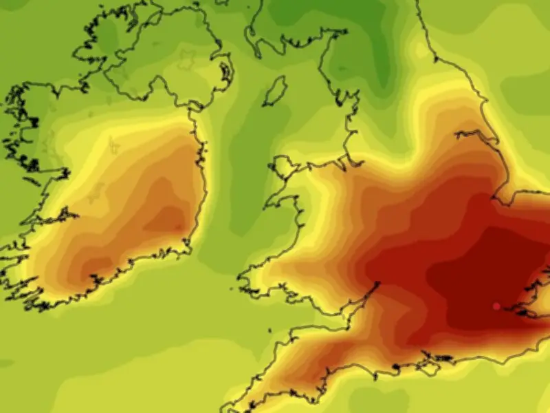
The UK is on course for the most intense heatwave of the summer so far, with temperatures expected to reach 38C on July 29, potentially the hottest day since 2022, according to forecasters. The scorching conditions will affect much of England, particularly Birmingham and the West Midlands conurbation, as shown by weather maps from WX Charts using ECMWF and GFS advanced modelling scenarios.
Heatwave Peak Date and Temperatures
The heatwave is projected to peak on July 29, with highs of 37C to 38C, making it the hottest spell of the year to date. The UK has already experienced three heatwaves this summer, including a week-long event in June that forced school closures and another at the end of May. July has also seen a heatwave earlier in the month.
Maps indicate temperatures soaring well above the seasonal average, with England depicted in deep red, tinged with black and burgundy, as the country faces another stifling hot spell.

Forecast Details and Expert Analysis
BBC presenter Ben Rich explained the meteorological drivers: "The Azores high, a semi-permanent large area of high pressure over the North Atlantic which can block weather fronts from reaching the UK, is likely to be close by. This will keep things drier further south, although not necessarily completely so."
Rich added: "Temperatures are most likely to remain above the seasonal norm, especially in England and Wales where further hot spells or heatwaves are possible into early August."
Outlook for Late July and Early August
A BBC outlook for July 27 to August 2 states: "From the end of July into the start of August, a similar broad pattern will most probably continue, with high pressure anomalies to the west and south-west, occasionally extending a ridge across the UK. However, it should weaken enough at times to allow Atlantic low pressure and frontal systems to bring periodic bands of rain, interspersed with brighter but showery episodes."
The wettest conditions are expected across northern UK, particularly Scotland, with stronger winds at times. Rainfall amounts will be lower elsewhere, and may be below average across southern England, though it is unlikely to be persistently dry, with occasional passing rain bands or showers. Some very warm days are still possible in the south, and temperatures elsewhere should overall be above or at least near normal.