
Fresh weather forecasts and meteorological maps are indicating the potential arrival of a significant new snow storm across the United Kingdom, with projections suggesting it could span an extensive 700-mile area. The latest data points towards widespread snowfall becoming a feature during the month of February, potentially affecting large swathes of the country.
Midlands Towns and Cities in the Path
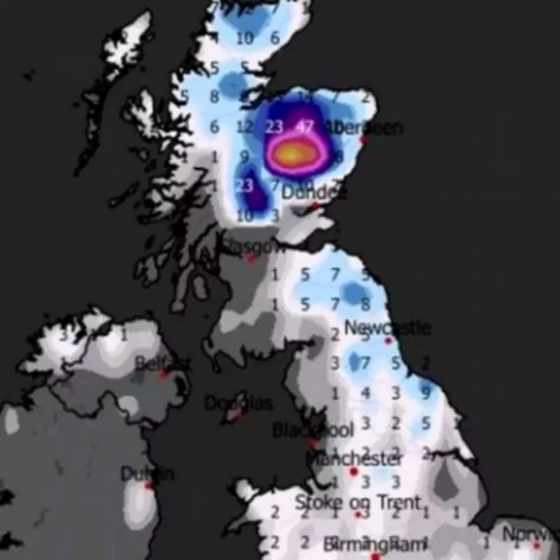
Detailed weather modelling, including charts from WXCharts for Friday, February 13, depict a scenario where almost the entirety of the UK could see a blanket of snow. This forecast specifically names the whole of the Midlands region as being within the projected path of the wintry weather. Major urban centres such as Birmingham, Wolverhampton, Coventry, and Stoke-on-Trent are highlighted as areas likely to experience the snowfall.
Current predictions for the Midlands suggest that if the snow materialises as forecast, it is expected to be predominantly light across the region, with accumulations estimated between 1 and 3 centimetres. However, the situation appears more intense further north, where flurries could be considerably heavier across parts of northern England and Scotland.

Met Office Long-Range Forecast Analysis
The Met Office has issued its long-range forecast covering the period from February 2 onwards. It indicates that the start of the month will continue in a similar vein to current conditions, characterised by largely unsettled weather. This pattern is expected to bring showers or longer spells of rain for many areas, accompanied by occasionally rather windy conditions.
The forecast notes: "Some hill snow is likely in the north too. Temperatures will be close to average for most, but perhaps rather cold in the far northeast." A subtle but significant shift is anticipated during the second half of this period, as wind directions are projected to change to a more easterly or northeasterly flow.
This atmospheric adjustment is likely to introduce colder conditions across the UK, with the Met Office stating: "It is likely to remain largely unsettled, especially towards the south, but it is likely to become colder with an increasing risk of snow, more particularly in the north." The forecast further warns that an often brisk wind will accentuate the colder feel for many.
Increased Risk of Wintry Hazards
Looking ahead to the period from February 12, the Met Office adds further detail to the evolving situation. Northwestern parts of the UK are deemed most likely to experience drier than normal conditions during this time. However, the forecast highlights a complex interaction of weather systems.
"Whilst incursions of wet, windy and milder weather are favoured at times in the south and later the west, colder conditions further north will bring an increased risk of wintry hazards," the Met Office explains. This risk is especially pronounced where any precipitation moving from the southwest interacts with the colder air mass established over northern regions. The authority cautions that these colder conditions may affect all parts of the country at times, particularly early in this forecast period.
Residents across the Midlands and the wider UK are advised to stay updated with the latest forecasts from the Met Office as February approaches, given the potential for disruptive winter weather and the increased risk of snow-related hazards indicated by the current projections.


