UK weather maps are indicating a new heatwave in July that could affect 17 counties, with temperatures potentially reaching 38°C. The GFS weather model suggests a four-day heatwave starting July 8, just days after the current heatwave subsides.
Current Heatwave Ends, New One Looms
The UK has experienced record-breaking temperatures this June, with yesterday marking the hottest day of the year so far and the most scorching June day ever recorded, as the mercury hit 37.3°C in Santon Downham. While temperatures are beginning to drop and should be back under 30°C across the country by Monday, the latest weather maps suggest the heat will return soon.
Predicted Dates and Temperatures
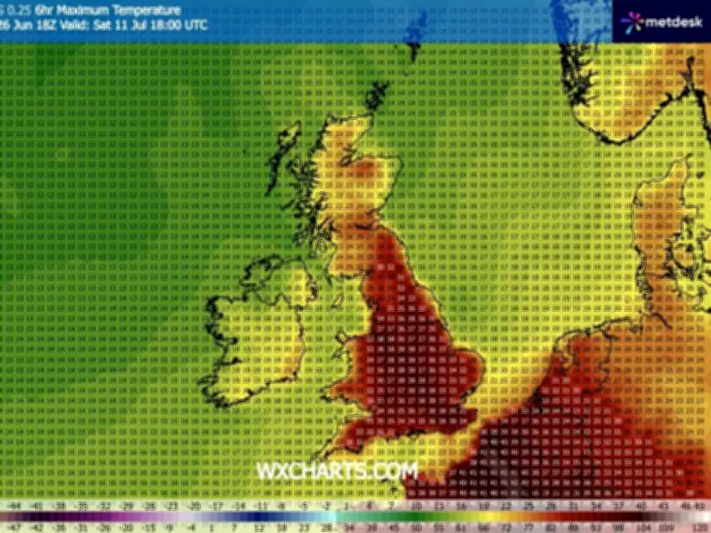
The GFS weather model predicts temperatures will begin rising above 30°C on July 8 in southern and western areas. The heat is expected to intensify on July 9, with 36°C predicted near London and 35°C widely across southern and eastern England. On July 10, searing highs of 38°C are forecast for western England and the south. Temperatures could once again climb to 38°C on July 11 across the north-west, Midlands, Yorkshire and the south-east.

17 Counties Expected to Be Affected
In total, GFS weather model maps indicate that 17 counties — all in England — could hit 38°C or higher. The affected counties are: Yorkshire, Cheshire, Staffordshire, Derbyshire, Leicestershire, Warwickshire, Northamptonshire, Shropshire, Gloucestershire, Worcestershire, Wiltshire, Berkshire, Oxfordshire, Buckinghamshire, Surrey, Sussex, and Kent.
Met Office Long-Range Forecast
The Met Office has released its long-range forecast for July, which suggests hot weather is likely. The forecast covering July 11 to 25 states: "High pressure patterns are looking slightly more likely than low pressure patterns during the early part of this period, meaning a greater chance of settled and drier than average conditions. Although with outbreaks of rain and stronger winds at times, more especially across the north. There is still a chance of some changeable or more unsettled conditions developing later in the period, with a risk of some heavy and thundery showers. Temperatures are likely to be above normal on the whole, with a greater than normal chance of hot conditions developing at times."