Deprivation Divide on a Single Road
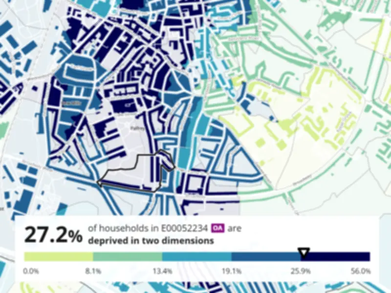
Latest Office for National Statistics (ONS) data show that a 1.5-mile stretch of the A4148 in Walsall separates some of the most affluent and deprived parts of the West Midlands borough. Areas along Broadway West in Palfrey and Broadway itself, both under the WS1 postcode, rank at opposite ends of the deprivation scale.
In Palfrey, near Broadway West, 27% of residents are deprived in at least two dimensions, according to the ONS. Just 1.5 miles up the road, where the A4148 becomes Broadway but still falls within WS1, the figure drops sharply to 4.7%.
Mapping the Contrast
ONS deprivation maps show streets in Palfrey shaded dark blue, indicating the highest deprivation levels, while streets near Broadway appear in light green, representing the lowest deprivation. The data underscores how a short distance can correlate with vastly different living conditions.

House Price Disparity
Property price data from housemetric.co.uk reflects the same trend. In 2023, a 76-square-metre property just off Broadway West in Palfrey sold for £172,000. By contrast, a 126-square-metre property near Broadway, purchased two years later in 2025, fetched £485,000. The price difference highlights how property values increase as one moves east along the A4148.
Jamie Brassington, senior reporter, noted that the data illustrates a stark economic divide within the same postcode area.