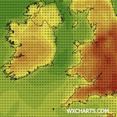
The Met Office has delivered its verdict on the weather for the week after temperatures have fallen and skies have greyed over Birmingham. The summer already feels like a memory, with the heatwave weekend behind us now, but there are signs it could be coming back.
Weekend Weather Outlook
The good news is the forecast is "fine and warm this weekend with strong sunshine at times," the weather authority stated. As for today, the Met Office adds: "Feeling rather warm in southern parts of the region with lengthy sunny periods. Somewhat cloudier, breezier and feeling cooler further north with a small chance of a light shower, especially across the Peak District. Maximum temperature 20 °C."
Tonight and Sunday
Moving into tonight, they continue: "A dry night will then follow with light winds for all by the early hours. A mix of cloud and clearer spells, a rather mild night for most. Minimum temperature 6 °C." On Sunday the weather will once again be fine with "light winds and a mix of fair weather cloud and sunny spells." However, it will be "a little warmer for most," with a maximum temperature of 22 °C.

Monday to Wednesday
From Monday to Wednesday, the Met Office states: "Dry with sunny spells on Monday. Cloudier from Tuesday with a little rain at times towards the north. Turning windier, especially by Wednesday. Remaining rather warm throughout."
Later Next Week
From there, it looks like the temperature will continue ticking up, with Thursday and Friday set to reach 24 °C. Long range weather forecasts predict "temperatures are likely to be above normal for most parts, and across the southeast in particular it could be very warm or hot at times, especially next weekend."
Further Outlook
From there, the temperature could rise further for the week starting Saturday June 27 to Saturday July 11. The Met Office adds: "Temperatures will likely be above normal, with the potential for hot conditions to develop, especially in the south."