The June heatwave that saw temperatures soar to 38C in parts of England is set to end on Sunday, with forecasts showing a significant drop to more comfortable levels. After days of sweltering conditions, households can expect relief as thermometers fall closer to the seasonal average.
Record-Breaking Heat
The heatwave shattered the record for the hottest June day on three consecutive occasions, with temperatures approaching 40C in some areas. According to weather forecasts, Saturday is likely to be the final day of extreme warmth across much of England, with the London and South East regions potentially reaching 32C, still uncomfortably hot for many. This means another warm night for households before the change arrives.
Cooling Trend from Sunday
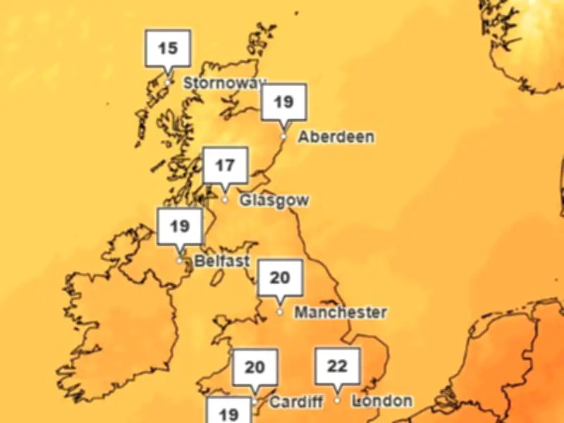
The picture shifts dramatically on Sunday, marking the end of the current heatwave. While conditions will remain warm and pleasant, temperatures are expected to fall to around 21C in the West Midlands by Sunday afternoon. This more comfortable level is set to persist for much of the following week, with temperatures hovering near this mark. The Met Office forecast for Monday to Wednesday states: "Feeling fresher for all. Largely dry with sunny spells, but a few showers possible, particularly on Tuesday and in the northwest. Light winds and feeling pleasant in the sunny spells."

Impact on Households
The drop in temperature should make warm and sticky households more bearable and improve sleep quality. However, forecasters have warned that "hot conditions" could return in the second half of July, so residents are advised to stay prepared for potential further heatwaves later in the summer.