The Met Office has escalated its weather alert for the West Midlands, upgrading a previous yellow warning to a more severe amber alert as Storm Goretti approaches. The region, including Birmingham and the Black Country, is now braced for potentially disruptive heavy snow from Thursday evening into Friday.
Amber Warning Details and Forecast Snowfall
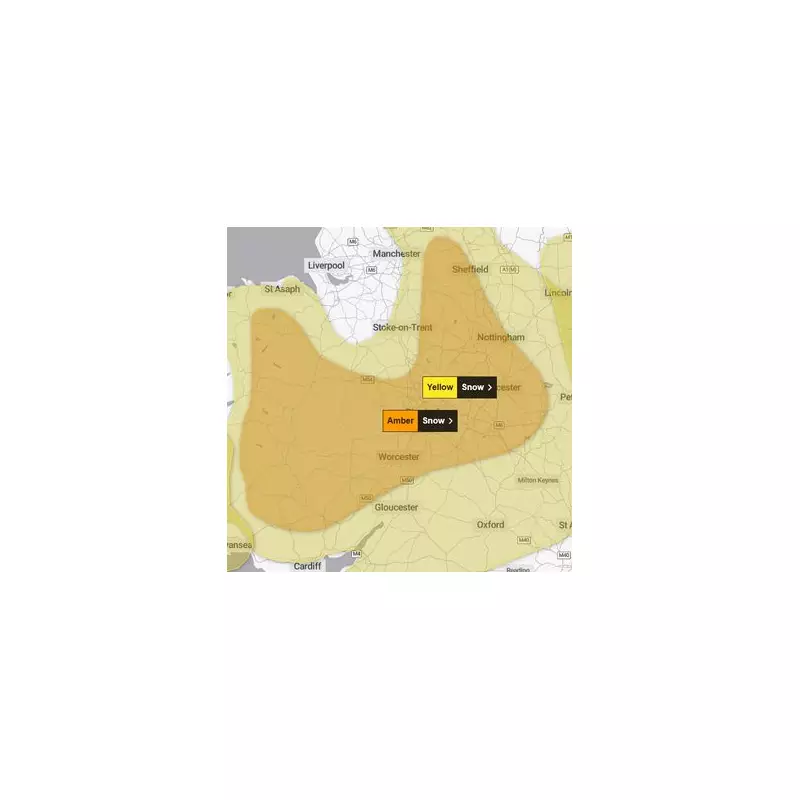
The national weather service has issued the amber snow warning for a period from 8pm on Thursday, January 8, until 9am on Friday, January 9. Forecasters warn that heavy snow associated with Storm Goretti is likely to cause significant travel disruption and dangerous conditions.
Within the amber zone, accumulations of 10 to 15 centimetres (four to six inches) are expected fairly widely. However, the Met Office indicates that some areas, particularly hills above 200 metres in Wales and the Peak District, could see staggering totals of 20 to 30 centimetres (eight to twelve inches).

Timeline of the Incoming Snow Event
The broader yellow warning area now starts earlier, at 5pm on Thursday, and extends through to midday on Friday. For Birmingham specifically, rain is predicted to turn to snow around 5pm on Thursday, with a 100% chance of snow persisting until 5pm on Friday.
The likelihood of precipitation will remain high throughout Friday morning, not dropping below 70% until 1pm and 50% until 3pm. This means disruption is expected to continue well after the peak amber warning period ends, affecting the Friday afternoon commute.
The Met Office stated: “Rain associated with Storm Goretti will turn readily to heavy snow on Thursday evening, initially on hills and then to lower levels overnight, before easing through the course of Friday morning.”
Wider Impact and Essential Travel Advice
The amber warning covers a large area, including the entire West Midlands and East Midlands, Gloucestershire, and parts of south and west Yorkshire. A significant portion of central Wales is also under the amber alert, with coastal areas remaining under the yellow warning.
Authorities are urging the public to prepare for hazardous conditions. Drivers considering travel are strongly advised to:
- Allow considerably more time for journeys.
- Pack an emergency kit including warm clothing, food, water, and a blanket.
- Carry essential items like a torch, ice scraper, warning triangle, and an in-car phone charger.
The Met Office has noted some uncertainty in Storm Goretti's exact track, which could shift the areas worst affected, and has warned that further updates to the warnings are possible. The storm was named by Meteo France due to its strongest winds being forecast over northern France.