The Met Office has issued a full list of 106 areas across the UK that will be affected by thunderstorms on Friday, marking the end of the current heatwave. Yellow weather warnings have been put in place, with potential disruption expected from Thursday night into Friday morning.
Thunderstorm Warnings in Effect
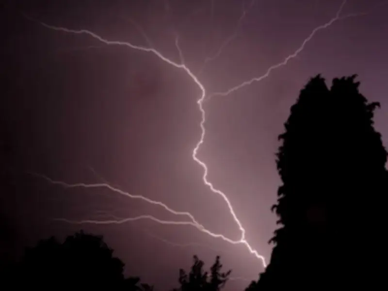
The Met Office has warned that while many areas will escape the worst of the storms, thunderstorms could still bring significant disruption. The warning is active from midnight on Thursday to midnight on Friday, lasting a full 24 hours. According to the Met Office, there is a slight chance of power cuts and loss of services to homes and businesses. Lightning strikes or flooding could cause delays and cancellations to train and bus services.
The statement added: "There is a small chance that homes and businesses could be flooded quickly, with damage to some buildings from floodwater, lightning strikes, hail or strong winds. Spray and sudden flooding could lead to difficult driving conditions and some road closures."

Affected Regions and Hazards
Thunderstorms are expected to move northeastwards across parts of England and Wales during the early hours of Friday, clearing by the morning. The Met Office noted: "Whilst many areas will miss them, thunderstorms may produce sudden, gusty winds with 50 to 60 mph possible, particularly in the south and west of the warning area. Frequent lightning, hail and heavy rain (possibly 15-20 mm in an hour) are additional hazards."
The full list of 106 areas includes major cities and regions such as Derby, Derbyshire, Leicestershire, Nottingham, Nottinghamshire, Hampshire, Oxfordshire, Darlington, Durham, Gateshead, Hartlepool, Middlesbrough, Newcastle upon Tyne, North Tyneside, Northumberland, Redcar and Cleveland, South Tyneside, Stockton-on-Tees, Sunderland, Blackburn with Darwen, Blackpool, Cheshire East, Cheshire West and Chester, Cumbria, Greater Manchester, Halton, Lancashire, Merseyside, Warrington, Bath and North East Somerset, Bournemouth Christchurch and Poole, Bristol, Devon, Dorset, Gloucestershire, North Somerset, Somerset, South Gloucestershire, Swindon, Torbay, Wiltshire, and all areas of Wales including Blaenau Gwent, Bridgend, Caerphilly, Cardiff, Carmarthenshire, Ceredigion, Conwy, Denbighshire, Flintshire, Gwynedd, Merthyr Tydfil, Monmouthshire, Neath Port Talbot, Newport, Powys, Rhondda Cynon Taf, Swansea, Torfaen, Vale of Glamorgan, and Wrexham.
Further Affected Areas
Additional areas in England include Herefordshire, Shropshire, Staffordshire, Stoke-on-Trent, Telford and Wrekin, Warwickshire, West Midlands Conurbation, Worcestershire, East Riding of Yorkshire, North Lincolnshire, North Yorkshire, South Yorkshire, West Yorkshire, and York. In Scotland, the warning covers Angus, Clackmannanshire, Dundee, Falkirk, Fife, Perth and Kinross, Stirling, Aberdeen, Aberdeenshire, Moray, Na h-Eileanan Siar, Highland, Orkney Islands, Dumfries and Galloway, East Lothian, Edinburgh, Midlothian Council, Scottish Borders, West Lothian, Argyll and Bute, East Ayrshire, East Dunbartonshire, East Renfrewshire, Glasgow, Inverclyde, North Ayrshire, North Lanarkshire, Renfrewshire, South Ayrshire, South Lanarkshire, and West Dunbartonshire.
Impact and Advice
Residents in these areas are advised to prepare for potential disruptions, including difficult driving conditions and possible road closures. The Met Office urges people to stay updated with the latest forecasts and take precautions against lightning, hail, and flooding.