
Fresh weather warnings are emerging for the United Kingdom as forecast maps predict another significant winter storm could strike before the end of January. The new system, spanning an estimated 700 miles, is projected to bring further heavy snowfall to regions still recovering from last week's severe weather.
Snow Maps Paint a Wintry Picture for Late January
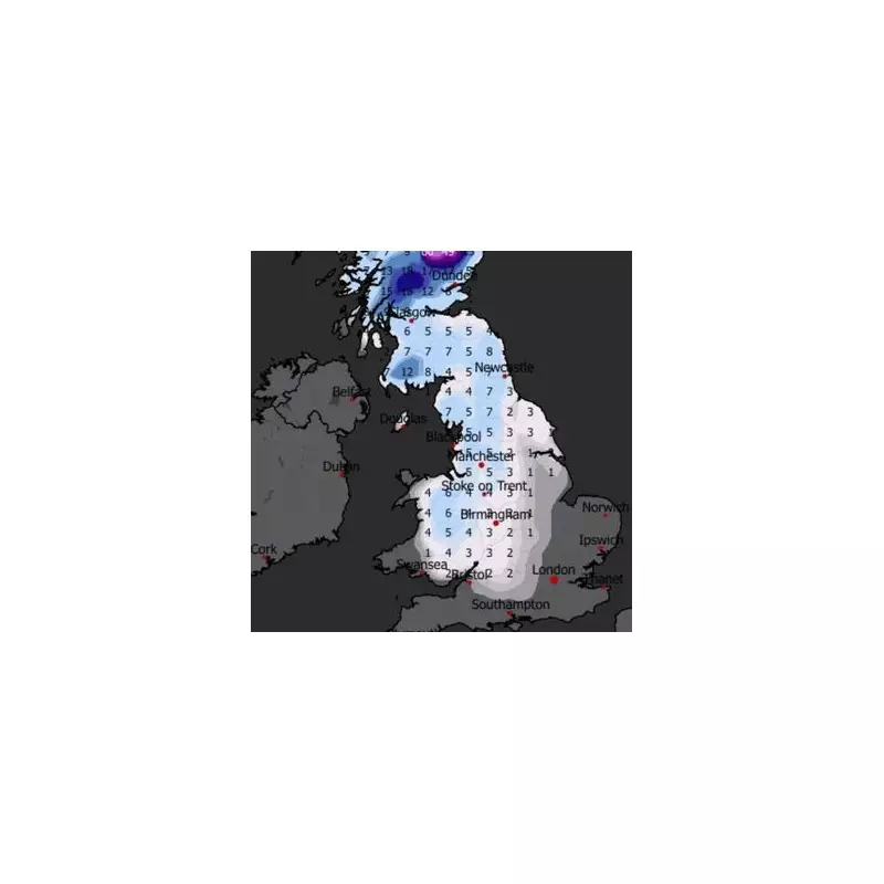
Latest data from weather modelling service WXCharts indicates that a major snow event will impact most of the country on Monday, January 26. The charts show a vast swathe of the UK, including the West Midlands, being blanketed in snow. For Birmingham and the surrounding area, accumulations of around 3 to 4 centimetres are currently anticipated.
Other parts of the region could see even deeper falls, with some forecasts suggesting up to 7cm (approximately 3 inches) may settle. The situation looks set to be more severe further north, with parts of Scotland in line for the heaviest snowfall of all.

Potential for Further Disruption After Storm Goretti
This new threat comes hot on the heels of Storm Goretti, which battered the nation last week with heavy snow, causing widespread travel chaos and disruption. The prospect of another major snowfall so soon raises concerns about renewed strain on transport networks and public services.
The Met Office has echoed these concerns in its long-range forecast for the end of January. While stating that temperatures will likely be near normal overall, it highlights the potential for "colder spells" and "associated winter hazards". The national forecaster warns that changeable conditions will probably persist, bringing further spells of rain and wind, particularly in western areas.
Official Forecast Warns of Winter Hazards
The Met Office outlook states: "Temperatures probably remaining close to average overall, but there is the possibility of colder conditions and associated winter hazards at times, due to higher pressure extending from the north or east."
It adds that by the very end of the period, a weather split may develop across the country, with wetter conditions concentrating in the north and northwest, while drier weather becomes established in the south and southeast.
Residents across the West Midlands and the wider UK are being advised to stay updated with the latest forecasts as the potential for this new winter storm becomes clearer in the coming days.


