
UK Braces for Widespread Snow as Met Office Issues Multiple Yellow Warnings
The Met Office has activated multiple yellow weather warnings for snow and ice across the United Kingdom, with forecast maps indicating that nearly 95% of the country could be covered by snow in the coming days. An Arctic maritime air mass is sweeping across the nation, bringing significant winter conditions that are expected to affect most regions.
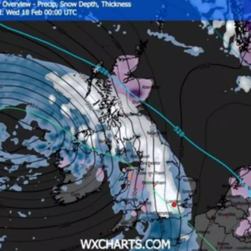
Extensive Snow Coverage Forecast
According to projections from WXCharts, by midnight on Wednesday, February 18, almost the entire UK is likely to be under a blanket of settled snow or experiencing active snowfall. Only isolated areas, such as parts of Cornwall, some coastal regions in Northern Ireland, and extreme northern edges of Scotland, are predicted to remain snow-free.
Weekend Warning Details and Accumulation Predictions
A yellow warning for snow and ice is in effect from 9 PM on Saturday, February 14, until 10 AM on Sunday, covering over 50 local authorities in the West Midlands, North West, North East, and Scotland. Rain moving eastwards tonight is expected to fall as snow initially, with accumulations forecasted at:

- 1–3 cm at low levels
- 3–7 cm above 150 meters
- 10–15 cm on ground higher than 400 meters
Impact on Major Cities and Temperature Drops
Urban centers including London, Birmingham, Manchester, Newcastle, Edinburgh, and Glasgow are all anticipated to see at least 1 mm of snow per hour during the peak of the weather front. Temperatures are set to plummet, with England ranging between -2°C and 4°C, while Scotland could experience lows as frigid as -11°C in areas like Perth and Kinross, Angus, and Aberdeenshire.
Additional Hazards and Travel Advice
Beyond snow, a secondary hazard of very slippery ice is expected, particularly in the North East, where rain may fall on frozen ground. There is also a risk of a short spell of freezing rain on Sunday morning before a steady thaw begins. Met Office Chief Forecaster Rebekah Hicks warned that snow is likely ahead of the rain and could reach lower levels tonight, with additional warnings possible as the front moves east and winds increase in coastal areas.
Motorists are strongly advised to carry emergency kits containing warm clothing, food, water, a blanket, and a torch, as snowy conditions are predicted to cause delays and dangerous driving surfaces on major routes such as the A66.


