
Jet2 Flight Diverts 600 Miles After Medical Emergency
A Jet2 flight from Glasgow to Lanzarote was diverted over 600 miles to Faro, Portugal, due to a passenger requiring urgent medical attention on July 16.

A Jet2 flight from Glasgow to Lanzarote was diverted over 600 miles to Faro, Portugal, due to a passenger requiring urgent medical attention on July 16.
All 3.2 million Blue Badge holders in the UK are exempt from the July hosepipe ban enforced across six water company areas, avoiding a £1,000 fine.
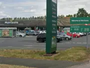
A woman was taken to New Cross Hospital with potentially serious injuries after a car-pedestrian collision at Morrisons Pendeford in Wolverhampton on July 13.
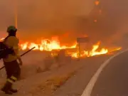
Two British hikers were found alive with 40% burns after Spanish wildfires near Bedar. At least 12 died, including four Britons. Rescuers heard faint cries.

Shared lists with real-time sync. No signup needed — just open and shop together.
Recommended
First Direct is closing its First Directory insurance add-on on July 31, 2026. Customers will have free cover extended until October 31, 2026, but must find alternatives after.
A man has died after falling from a construction site at Birmingham Children's Hospital. Police and HSE are investigating the incident.

An adult has died from measles in the West Midlands as cases continue to rise, with the region reporting the highest number of infections in England.
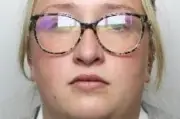
A prison worker has been jailed for illegally accessing records of notorious killers Lucy Letby and Rose West while employed at HMP Birmingham.

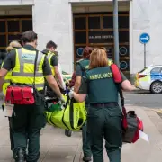
West Midlands Ambulance Service has deployed additional ambulances to cope with extreme heat and World Cup-related demand, with over 3,000 calls on one Sunday alone.
Shared lists with real-time sync. No signup needed — just open and shop together.
Recommended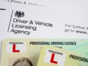
The London Assembly has urged the Labour government to ban provisional licence holders from using L plates for commercial work, citing safety risks from food delivery riders on repeatedly renewed CBT certificates.

A man was resuscitated by an off-duty paramedic and ambulance crews at Pure Gym in Brierley Hill after suffering a medical emergency on July 7.
A woman suffered potentially serious injuries in a four-vehicle crash on the M42 near Sutton Coldfield. She was rushed to Heartlands Hospital after the collision between junctions 10 and 9.

An 18-month-old boy who fell into a swimming pool was mistakenly declared dead and placed in a body bag, only to be discovered alive nearly six hours later in a hospital mortuary.
Anthony Thomas 'TJ' Hoover, declared brain dead after a drug overdose, regained consciousness and cried as doctors prepared to remove his organs for transplant in Kentucky.
Shared lists with real-time sync. No signup needed — just open and shop together.
Recommended
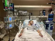
Racing legend Frankie Dettori was taken to hospital with broken ribs and a broken thumb after his car was struck and flipped in Newmarket, Suffolk, on Wednesday evening.

Ticks are becoming more common on the Sefton Coast due to increasing Roe Deer numbers. Learn how to protect yourself from these tiny pests and the diseases they may carry.
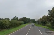
A 14-year-old boy suffered serious injuries in a single-vehicle crash on the A442 near Bridgnorth. A man has been arrested on suspicion of causing serious injury by dangerous driving.

Tesco and Lidl have recalled ham products from their premium ranges due to possible listeria contamination, affecting Brady Family items and others with use-by date July 16.

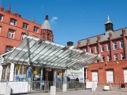
Queen Elizabeth University Hospital in Glasgow enters lockdown after a patient with recent travel to an Ebola-affected country presents with concerning symptoms; testing underway.
Shared lists with real-time sync. No signup needed — just open and shop together.
Recommended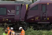
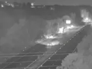
A train passed a red signal before a crash that killed the driver and injured 100 passengers near Birmingham, an investigation has revealed.
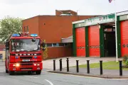
West Midlands Fire Service warns drivers to take precautions amid heatwave, including carrying water and planning journeys to avoid breakdowns and fires.
A major incident has been declared after a bus crash on the A484 in Kidwelly, Carmarthenshire, with reports of at least 26 people injured and air ambulances on scene.
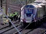
Shaun Burton, 60, the East Midlands Railway driver killed in Friday's collision near Bedford, has been identified. The crash injured 100 people, with 11 seriously hurt.
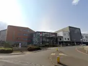
Walsall Manor Hospital will conduct an emergency response test on June 24, involving shouting and loud noises. Services will continue as normal.
Shared lists with real-time sync. No signup needed — just open and shop together.
Recommended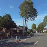
A man was taken to hospital after a medical incident on Moat Road in Oldbury. Emergency services found him in a potentially serious condition.
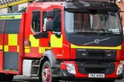
West Midlands Fire Service responded to a house fire on a residential street in Birmingham. No injuries reported, but residents were evacuated as crews battled the flames.

Nationwide is equipping all 605 UK branches with defibrillators and bleed control kits, partnering with Visa and St John Ambulance to train staff and communities.
Around 1,000 personnel participated in 'Firebird', the largest terror attack exercise in modern times, at London's Canary Wharf to test emergency response capabilities.
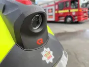
Firefighters from four crews tackled a blaze at a derelict building in the West Midlands. No injuries reported as crews work to prevent spread.
Shared lists with real-time sync. No signup needed — just open and shop together.
Recommended
Nationwide partners with Visa to install defibrillators and bleed control kits in 605 branches, offering training to staff and communities.
